
The United States Geological Survey
recorded a Magnitude 4.7 Earthquake at a depth of about 21.0 km roughly 5 km off the coast of Humboldt County,
California, slightly before 8.10 pm local time on Thursday 22 March 2018 (slightly before 3.10 am on Friday 23 March GMT). There
are no reports of any damage or injuries relating to
this quake, but people have reported feeling it across much of northern
California.

The approximate location of the 22 March 2018 Humboldt County Earthquake. USGS.
California
is extremely prone to Earthquakes due to the presence of the San
Andreas Fault, a tectonic plate margin that effectively bisects the
state. The west of California, including Santa Barbara and Los Angeles,
is located on the Pacific Plate, and is moving to the northwest. The
east of California, including Fresno and Bakersfield is on the North
American Plate, and is moving to the southeast. The plates do not move
smoothly past one-another, but constantly stick together then break
apart as the pressure builds up. This has led to a network of smaller
faults that criss-cross the state, so that Earthquakes can effectively
occur anywhere.
However the 22 March 2018 Earthquake happened on the southern part of the Cascadia
Subduction Zone, a northward extension of the San Andreas Fault, where
the Gorda Plate is being subducted beneath the North American Plate. Along
this boundary the rocks of the two plates continuously stick together,
then become stressed as the motion of the two plates draws them apart.
This stress builds up until the rocks are forcibly snapped apart, which
we experience as Earthquakes.
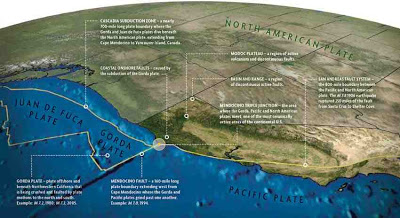
Map showing the progress of the San Andreas Fault to the north, where it becomes the Gorda Plate subduction zone. Humboldt State University.
The Gorda Plate, along with the Explorer
and Juan de Fuca Plates are remnants of an ancient oceanic plate, the
Fallaron Plate which has almost completely disappeared beneath North
America. The Fallaron Plate formerly diverged from the Pacific Plate
along the Fallaron Ridge, but as the plate has been subducted both it
and the ridge have broken up. The remnants of the plate are now the
Explorer Plate in the north, then the Juan de Fuca Plate, then the Gorda
Plate in the south. This borders onto the Pacific Plate along the
Mendocino Fracture Zone, which extends on land as the San Andreas Fault.

North of California the San Andreas Fault becomes the Mendocino Fracture Zone. USGS.
Witness
accounts of quakes can help geologists to understand these events and
the rock structures that cause them. If you felt this quake (or if you
were in the area but did not, which is also useful information) you can
report it to the USGS here.
See also...


Follow Sciency Thoughts on
Facebook.