
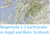
The British Geological Survey recorded
a Magnitude 2.6 Earthquake at a depth of about 7 km, in the Knapdale district of Argyl and Bute, Scotland, roughly 3 km to the north of the village ot Tarbert, at slightly before 9.00 am GMT on Wednesday 1 November 2017. This was not a major
event, and presented no
threat to human life or property, but was been felt locally.

The approximate location of the 1 November 2017 Tarbert Earthquake. Google Maps.
Earthquakes
become more common as you travel north and west in Great Britain, with
the west coast of Scotland being the most quake-prone part of the island
and the northwest of Wales being more prone to quakes than the rest of
Wales or most of England.
The
precise cause of Earthquakes in the UK can be hard to determine; the
country is not close to any obvious single cause of such activity such
as a plate margin, but is subject to tectonic pressures from several
different sources, with most quakes probably being the result of the
interplay between these forces.
Britain
is being pushed to the east by the expansion of the Atlantic Ocean and
to the north by the impact of Africa into Europe from the south. It is
also affected by lesser areas of tectonic spreading beneath the North
Sea, Rhine Valley and Bay of Biscay. Finally the country is subject to
glacial rebound; until about 10 000 years ago much of the north of the
country was covered by a thick layer of glacial ice (this is believed to
have been thickest on the west coast of Scotland), pushing the rocks of
the British lithosphere down into the underlying mantle. This ice is
now gone, and the rocks are springing (slowly) back into their original
position, causing the occasional Earthquake in the process.


Witness
accounts of Earthquakes can help geologists to understand these events,
and the structures that cause them. If you felt the 24 January quake, or were in
the area but did not (which is also useful information) then you can
report it to the British Geological Survey here, or if you felt the 25 January or were in
the area but did not (which is also useful information) then you can
report it to the British Geological Survey here.
See also...


Follow Sciency Thoughts on Facebook.