
Residents of villages close to Mount Sinabung on North Sumatra have been forced to evacuate their homes following two eruptions on the volcano on Thursday 25 February 2016. The first eruption occured at about 6.45 pm the second slightly after 11.20 pm. Both produced ash columns reaching about 2 km above the summit of the mountain, and threw hot ash and lava up to 500 m from the crater.

An ash column over Mount Sinabung on 25 February 2016. Dedi Sahputra/SAPO.
Mount Sinabung, a 2460 m stratovolcano (cone shaped volcano made
up of layers of ash and lava) in the Karo Regency; it is potentially a
very dangerous volcano, as a large number of people live in its
immediate vicinity. The last major eruption prior to the twenty-first
century happened in about 1600, with small eruptions occurring in 1889
and 1912. However the volcano returned to life in late August 2010,
erupting throughout September and causing about 12 000 people to flee
their homes.

The location of Mount Sinabung. Google Maps.
The
Indo-Australian Plate, which underlies the Indian Ocean to the west of
Sumatra, is being subducted beneath the Sunda Plate, a breakaway part of
the Eurasian Plate which underlies Sumatra and neighboring Java, along
the Sunda Trench, passing under Sumatra, where friction between the two
plates can cause Earthquakes. As the Indo-Australian Plate sinks further
into the Earth it is partially melted and some of the melted material
rises through the overlying Sunda Plate as magma, fueling the volcanoes
of Sumatra.

The Subduction zone beneath Sumatra. NASA/Earth Observatory.
This
does not happen at a 90° angle, as occurs in the subduction zones along
the western margins of North and South America, but at a steeply
oblique angle. This means that as well as the subduction of the
Indo-Australian plate beneath the Sunda, the two plates are also moving
past one-another. This causes rifting within the plates, as parts of
each plate become stuck to the other, and are dragged along in the
opposing plate's direction. The most obvious example of this is the
Sumatran Fault, which runs the length of Sumatra, with the two halves of
the island moving independently of one-another. This fault is the cause
of most of the quakes on the island, and most of the island's volcanoes
lie on it.

The movement of the tectonic plates around Sumatra. NASA/Earth Observatory.
See also...
 Thousands of new evacuations from villages around Mount Sinabung, Sumatra. Authorities on the Indonesian island of Sumatra have begun to evacuate
people from four villages to the south and southeast of Mount
Sinabung, an active...
Thousands of new evacuations from villages around Mount Sinabung, Sumatra. Authorities on the Indonesian island of Sumatra have begun to evacuate
people from four villages to the south and southeast of Mount
Sinabung, an active...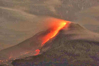 Further evacuations on North Sumatra as Mount Sinabung continues to erupt. The number of people evacuated from villages around Mount Sinabung, an
active volcano on North Sumatra, has risen to around 20 000 following a
series of about 50 eruptions over the first...
Further evacuations on North Sumatra as Mount Sinabung continues to erupt. The number of people evacuated from villages around Mount Sinabung, an
active volcano on North Sumatra, has risen to around 20 000 following a
series of about 50 eruptions over the first... 
Over
6300 people have been evacuated following a series of nine eruptions on
Mount Sinabung, northern Sumatra, Indonesia on Saturday 23-Sunday 24...
Follow Sciency Thoughts on Facebook.