
Ten people have been confirmed dead and 63 have been injured following an unpredicted eruption of Mount Ontake on central Honshū on Saturday 27 September 2014. At least 26 people remain unaccounted for on the volcano, which is a popular tourist attraction and was packed with tourists, many of whom were families with children, at the time of the eruption. Searches for survivors have had to be called off today (Monday 29 September) due to fears of toxic gas being emitted by the volcano. While many of the injured are reportedly suffering from broken limbs or similar injuries sustained during the rapid evacuation of the mountain, the major cause of fatalities is likely to be asphyxiation due to fine ash falling on unwary hikers.

Tourist lodges covered with ash on Mount Ontake. Reuters.
Ontake is the second highest volcano in Japan at 3067 m, and for most of its history has been considered inactive. However it erupted in 1979-80 producing around 200 000 tons of ash, and since then as undergone minor eruptions in 1991, 2007 and 2008, though there has been no precedent for the September 2014 eruption.
Japan has a complex tectonic environment with four plates underlying
parts of the Islands; in addition to the Pacific in the east and the
Okhosk in the North, there are the Philippine Plate to the south and the
Eurasian Plate to the West. Kyūshū Island lies at the northeast end of
the Ryukyu Island Arc, which sits on top of the boundary between the
Eurasian and Philippine Plates. The Philippine Plate is being subducted
beneath the Eurasian Plate, in the Ryukyo Trench, to the Southeast of
the Islands. This is not a smooth process, with the two plates
continuously sticking together then breaking apart as the pressure builds
up, leading to frequent Earthquakes in the region.

The movement of the Pacific and Philippine Plates beneath eastern Honshu. Laurent Jolivet/Institut des Sciences de la Terre d'Orléans/Sciences de la Terre et de l'Environnement.
See also...
The Japan Meteorological Agency recorded a Magnitude 6.1...
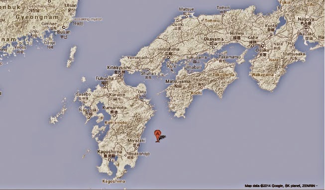
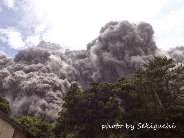 Eruption and pyroclastic flow on Mount Furudake. The Japan Meteorological Agency recorded an eruption on Mount Furudake on Kuchinoerabujima, an island
about 130 km south of Kagoshima, at about 12.25 pm local time on Sunday 3
August 2014. The eruption consisted of a single powerful explosion
followed by the...
Eruption and pyroclastic flow on Mount Furudake. The Japan Meteorological Agency recorded an eruption on Mount Furudake on Kuchinoerabujima, an island
about 130 km south of Kagoshima, at about 12.25 pm local time on Sunday 3
August 2014. The eruption consisted of a single powerful explosion
followed by the... Magnitude 5.5 Earthquake in Iwate Prefecture, Japan. The Japan Meteorological Agency recorded a Magnitude 5.5 Earthquake at a
depth of 90 km in eastern Iwate Prefecture on northern Honshū Island,
Japan, slightly after 2.35...
Magnitude 5.5 Earthquake in Iwate Prefecture, Japan. The Japan Meteorological Agency recorded a Magnitude 5.5 Earthquake at a
depth of 90 km in eastern Iwate Prefecture on northern Honshū Island,
Japan, slightly after 2.35...
Follow Sciency Thoughts on Facebook.